Dunsmuir River Trail
- The Slow Hiker
- Nov 7, 2024
- 5 min read
I found this trail on the Hike Mt. Shasta website and, since it had been raining, it sounded like a good choice. Well, turns out, this 1.4 mile trail turned into 3 miles over two days. Yes, my friends, I got lost.
Just like the directions advised, I started out at Tauhindauli Park, crossed over a small footbridge, and followed the path under the I-5 bridge. In fact, I passed under both northbound and southbound I-5. But let's back-up. Even if you ignore the fact that this is basically a construction zone right now, the park is located in the weirdest place. The parking area, picnic tables, and even grills are situated in the shade provided by the southbound I-5 bridge, and there is a path with informational signs throughout the park, which encircles someone's home. It's odd.

Now back to the footbridge. I crossed over the only one I saw and continued following the path down to the left. After passing the pump station, I had the choice of continuing on a paved path to the left or following a dirt path down to the river. I went both ways; the beginning of the path was supposed to be paved so at first I went up the paved path and then, since the trail was supposed to follow the river, I went down the dirt path, but the path ended, so I went back up the paved path. I was really getting my steps in!


At the top of the hill, I arrived at what looked like a road. Nowhere in the directions was a road mentioned, but there was supposed to be a little wheelchair accessible area, so I continued on...and on, and on. Don't get me wrong, the views were stunning and walking on a paved road after rain was not horrendous. But I wasn't seeing ANYTHING that resembled the directions. Still, I walked, past forest, and river, and fallen trees, and then I came to houses, and then I came to a bridge. Like a bridge that cars drive over.
Always on to admire the view from a bridge, I meandered out to the middle (quickly stepping out of the path of a speeding truck, literally the only vehicle I had seen this whole time) and took in the sights and sounds of the rushing Sacramento River. Gorgeous. You can't even tell that there are several sets of railroad tracks on one side and homes on the other.


By this time I knew something was wrong. I pulled up the directions to look at the little photo of a map that was included and then consulted my friend Google to find my location dot on his map. Yeah, that cleared things up; I was supposed to follow the path to the right way back at the parking lot. No, my friends, at no point during this 1/2 mile slow hike did I realize that the water was supposed to be to my left.
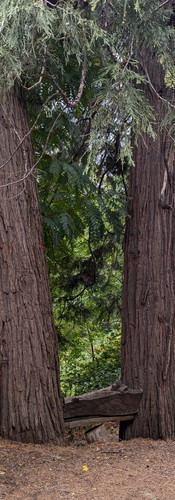
Resigned to return and go on the actual River Trail, I turned around, increased my pace, and followed the road back to the parking lot. If I had not taken that wrong turn, I would most likely have trekked through mud, and I wouldn't have seen these gorgeous views. I mean, look at this adorable bench someone made between two pines, and the tree growing out of the side of the cliff. Definitely not the road I was "supposed" to be on, but I'm not mad that I got lost.

Ok, so let's talk about my return trip. The sun was out, it was warm, I made it back to the park under the freeway, and this time I turned to the right and headed past the electric plant. (Weird location, remember?) I immediately saw the path that led to the Accessible ramp down to the water. I made a quick stop to check out the view, and then backtracked to the main path. After curving around the house I mentioned earlier, the pavement came to an end and the path continued through the woods.

At first the trail zigzagged back up to the road that I took to get to the park, but then I saw a "no trespassing" sign on a fence blocking a sidewalk and a narrow trail to the left. Because I had already been so successful in reading the directions, I checked them one more time before choosing the narrow path. Now the directions on the website clearly state, "Be sure to use caution since the slope drops off steeply from the trail." Honestly, that was an understatement. There were a couple of places where the trail was completely sketchy...like when a tree was growing out of the side of the mountain and someone had piled a bunch of small rocks underneath it for support, and when I had to step over some roots of a tree and, when I looked up to thank the tree for the stability, I realized it had been cut down.
I'm not usually one to do things that scare me, but I stepped over those roots, said thank you for stability and life (This might have been the Giving Tree, folks!), and continued on. I ran into a few swarms of tiny insects so I pulled out my old lady fan to keep them away from my face, and passed all of the places along the trail that were mentioned in the directions; boards covering a stream, the amphitheater, boulders with plaques attached, and steps leading up to the Botanical Gardens. I even ventured down a few paths to get up close and personal with the river.


Totally worth it!
I decided to continue past the Botanical Gardens little further to see some giant boulders and try to catch a glimpse of Mt. Shasta. I came to a parking lot where there were several people fishing down in the river and followed the trail to the boulders. As promised, Mt. Shasta was peeking down at me in approval.

After lingering in the calm of the mossy rocks and rushing river, I turned around to retrace my steps. One of the fishermen was reeling in a fish as I passed. As many times as I have stopped to gaze in the river, I have never seen a fish. I will have to look harder next time.
And, no matter how often I get lost, I am always reminded to enjoy the journey, because that's what life is all about.
Difficulty: | Easy. Part of the trail is really narrow and the drop is steep. |
Length: | 1.4 according to Hike Mt. Shasta. Google says it's 1/5 if you go all the way to the boulders |
Parking: | The lot at Tauhindauli Park is small but free. I didn't check parking at the Botanical Gardens. |
Facilities: | Picnic tables and grills next to the parking lot at the park. There was also a port-a-potty, but that might have been for the construction workers. |
Fees: | None. |
Visited: | September 2024 |


Comments