Shasta Mountain Archery Trail
- The Slow Hiker
- Mar 19
- 3 min read
I have been so busy searching for a Pacific Sunset that I haven't been on a local trail in a pretty long time. So, when a friend invited me to join them on the trail as they shot some targets on the Shasta Mountain Archers field course, I was all in. Just the drive, with the layers of pine trees climbing up the mountain in front of me, and the snow-capped volcano shrouded in a ring of clouds jutting to the sky above them, was enough to put a smile on my face and remind me what I love about this area. It doesn't matter where you're driving, what kind of road you're on, what direction you are heading, there is always a picturesque view to be seen.

This beautiful drive led me to an unmarked, dirt road and a hidden parking area off to the side. Shockingly, I did not get lost on the way - this is partly because my friend ended up right behind me and I watched for his blinkers so I would know where to turn. Look, whatever works, right?
We have had very little snow, and the weather has been unseasonably warm, so the parking area, and most of the trail, was covered in fallen leaves and pine needles. I was worried that there wouldn't be very much to look at this time of year, but the flowering plants were starting to bud and the bare branches on the deciduous trees were still covered in winter moss and allowed a gorgeous view of the green pine trees against the pale blue sky. Before we even headed out onto the trail, I caught a glimpse of Mount Shasta watching over us.


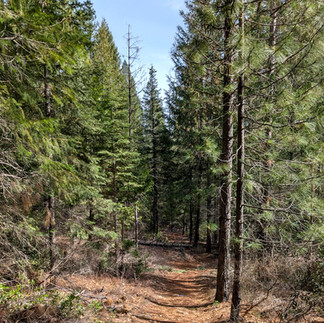


Following the signs to the first target, I was surprised to see that there was a bridge crossing a tiny little creek. I don't know why I was surprised, I think there has been water on every adventure I have gone on in this area. Still, it was wonderful to stop and listen to the trickle of the stream heading down the mountain.


We continued on the trail, which had lots of twists and turns and ups and downs, and I started wondering (as I often do) how this trail came to be. I think about this on highways, too. But these make more sense to me. Hundreds of years ago, a very similar path was used by natives and settlers to get from one place to another so the path was created and the road was built and widened so now we can speedily get from one place to another. But how do these random trails happen in the middle of the forest on the side of a mountain? What makes someone choose to go right or left at any given spot? And are we all so similar that the majority of people make those same choices, which results in a trail? I really do spend a ridiculous amount of brain power trying to figure this stuff out sometimes. And also, yay for the people who forge the path so I have a place to explore.

Anyway...after cheering for my friends when they hit the target, helping to search for arrows that went astray, discussing the best way each of us had found to get up steep hills, and sharing our tips on how to save old knees on downhill paths, we decided it was time to head back to the parking lot. Since we didn't complete the entire Archery course, we veered off the trail and headed down the access road. Normally I would say that walking down a road isn't as exciting as hiking on a trail, but the width of the road opened up the forest canopy and left us with a spectacular view of Mount Shasta as our parting gift. There will never be a day when I am not in awe of the magnitude and sheer beauty of this mountain.


Comments